
Surrey, East & West Sussex A-Z Visitors' Map
No Customer Reviews

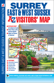
This full colour visitors' map of Surrey, East Sussex & West Sussex features road mapping that covers an area extending to:*The south coast from Portsmouth to Hastings*Ashford (Kent) and Faversham to the east*Reading, central London, Gravesend and Sheerness to the north*Fareham and Basingstoke to the west.Map detail is shown at a clear 2.5 miles to 1 inch scale (1.6 kms to 1 cm) and includes the following features:*Motorways, service areas, primary routes and destinations, A & B roads, tolls, mileages, gradients 1:5 and steeper and county boundaries.*Full major road junction detail.*Selected safety camera locations with their maximum speed limits and fuel stations.*Selected places of interest, tourist information centres, caravan and camping sites and golf courses.*Areas of Outstanding Natural Beauty and the boundary to the UK's newest National Park, the South Downs National Park, are also shown.There are 2 separate index panels adjacent to the mapping:*An index to cities, towns, villages, hamlets and locations*A comprehensive places of interest index with the corresponding map symbol shown alongside each entry for easy identification.
Format:Paperback
Language:English
ISBN:1782570241
ISBN13:9781782570240
Release Date:July 2014
Publisher:Geographers' A-Z Map Company Ltd.
Length:1 Pages
Related Subjects
TravelCustomer Reviews
0 rating
Copyright © 2026 Thriftbooks.com Terms of Use
| Privacy Policy | Do Not
Sell/Share My Personal Information | Cookie Policy | Cookie Preferences | Accessibility Statement
ThriftBooks® and the ThriftBooks® logo are registered trademarks of Thrift Books Global, LLC
ThriftBooks® and the ThriftBooks® logo are registered trademarks of Thrift Books Global, LLC
