
Rand McNally Easy to Read: South Carolina State Map
No Customer Reviews

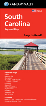
Rand McNally's folded map for South Carolina is a must-have for anyone traveling in or through the state, offering unbeatable accuracy and reliability at a great price. Our trusted cartography shows all Interstate, U.S., state, and county highways and much more. - Points of interest. - State park chart. - State mileage chart. - Driving times map. - Visitor center information. - Climate data. - State facts & symbols. - Easy-to-use legend. - Detailed indexed. Coverage Area Detailed maps include: Aiken, Charleston, Columbia, Greenville, Hilton Head Island, Myrtle Beach, North Augusta/Augusta, GA; Rock Hill, Spartanburg. Product Details: Measures 9.0" x 4.125" and folds out to 25.5" x 36.75".
Format:Loose Leaf
Language:English
ISBN:0528028723
ISBN13:9780528028724
Release Date:February 2024
Publisher:Rand McNally
Length:1 Pages
Weight:0.05 lbs.
Dimensions:0.5" x 4.0" x 9.2"
Recommended
Format: Loose Leaf
Condition: New
$8.41
Save $1.58!
List Price $9.99
On Backorder
If the item is not restocked at the end of 90 days, we will cancel your backorder and issue you a refund.
Usually restocks within 90 days
Not eligible for Free Shipping 
Save to List
Related Subjects
ReferenceCustomer Reviews
0 rating
Copyright © 2026 Thriftbooks.com
Terms of Use | Privacy Policy | Do Not Sell/Share My Personal Information | Cookie Policy | Cookie Preferences | Accessibility Statement
ThriftBooks ® and the ThriftBooks ® logo are registered trademarks of Thrift Books Global, LLC
ThriftBooks ® and the ThriftBooks ® logo are registered trademarks of Thrift Books Global, LLC
