
Rand McNally: Columbus/Cincinnati, Ohio Regional Map
No Customer Reviews

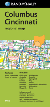
Rand McNally's folded map for Columbus Cincinnati is a must-have for anyone traveling in and around this part of Ohio, offering unbeatable accuracy and reliability at a great price. Our trusted cartography shows all Interstate, U.S., state, and county highways, along with clearly indicated parks, points of interest, airports, county boundaries, and streets. The easy-to-use legend and detailed index make for quick and easy location of destinations. You'll see why Rand McNally folded maps have been the trusted standard for years.
Regularly updated
Full-color maps
Clearly labeled Interstate, U.S., state, and county highways
Indications of parks, points of interest, airports, county boundaries, downtown & vicinity maps
Major attractions & Golf Courses
Enlargements of Cincinnati downtown, Columbus downtown, Dayton downtown, Port Columbus Int'l Airport, Cincinnati-Northern Ky. Int'l Airport
Easy-to-use legend
Detailed index & Major Street Index
Convenient folded size
Copyright 2019
Coverage Area
Chillicothe, Circleville, Dayton, Fairfield, Hamilton, Hillsboro, Lancaster, Marysville, Middletown, Rossville, Springfield, Troy, Urbana, Washington Court House, Wilmington, Xenia
Product Details
Measures 9.5" x 4" and folds out to 40" x 28"
Format:Map
Language:English
ISBN:0528008919
ISBN13:9780528008917
Release Date:January 2019
Publisher:Rand McNally
Length:2 Pages
Weight:0.10 lbs.
Dimensions:0.5" x 4.1" x 8.8"
Related Subjects
TravelCustomer Reviews
0 rating
Copyright © 2026 Thriftbooks.com Terms of Use
| Privacy Policy | Do Not
Sell/Share My Personal Information | Cookie Policy | Cookie Preferences | Accessibility Statement
ThriftBooks® and the ThriftBooks® logo are registered trademarks of Thrift Books Global, LLC
ThriftBooks® and the ThriftBooks® logo are registered trademarks of Thrift Books Global, LLC
