
National Geographic Hawaii Wall Map (34.75 X 22.75 In)
No Customer Reviews

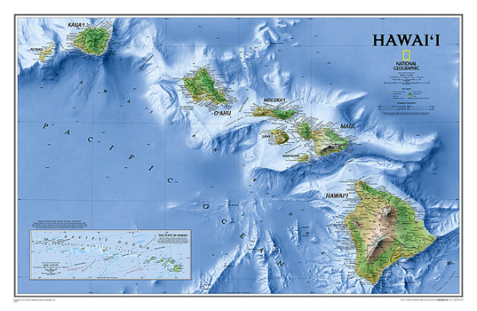
One of Expertly researched and designed, National Geographic's most visually stunning maps, the Hawai'i Map shows all eight of the major islands and includes an inset of the entire chain of reefs stretching nearly 3,000 miles across the central Pacific. In addition to showing all of the major land features, the map also shows the Hawaiian Ridge that runs under the islands, providing a wonderful perspective on how they were formed.
The map is packaged in a two inch diameter tube with a label showing a thumbnail of the map with dimensions and other pertinent information.
Map Scale = 1:819,000Sheet Size = 34.75" x 22.75"Format:Misc.
Language:English
ISBN:0792249666
ISBN13:9780792249665
Release Date:November 2017
Publisher:National Geographic Maps
Length:1 Pages
Weight:1.10 lbs.
Dimensions:3.3" x 3.3" x 37.0"
Recommended
Format: Misc.
Condition: New
$18.96
Save $5.99!
List Price $24.95
Almost Gone, Only 1 Left!
Ships within 24 hours
Not eligible for Free Shipping 
Save to List
Related Subjects
ReferenceCustomer Reviews
0 rating
Copyright © 2026 Thriftbooks.com
Terms of Use | Privacy Policy | Do Not Sell/Share My Personal Information | Cookie Policy | Cookie Preferences | Accessibility Statement
ThriftBooks ® and the ThriftBooks ® logo are registered trademarks of Thrift Books Global, LLC
ThriftBooks ® and the ThriftBooks ® logo are registered trademarks of Thrift Books Global, LLC
