
Moosehead Lake Depth Maps

See the depths of Moosehead Lake in Full Color
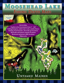
The Moosehead Lake depth maps are here The Moosehead Lake Depth Map Atlases offer detailed 1-foot depth increments to show the contours of the bottom in full color, making it easy to find drop-offs, shallow areas, deep basins, and underwater mountains. The maps include the locations of underwater rock hazards, islands, fishing hotspots, parking, trailered & hand-carry boat launches, water-accessible fuel, picnic tables, restrooms, campsites, shipwrecks (in books 2 and 4), hazard buoys, channel buoys, no-wake zones, and the two-mile light buoy.
These maps are perfect if you love fishing, boating, canoeing, kayaking, camping, diving, & adventure on Moosehead Lake
The maps include the locations of:
Underwater rock hazardsFishing hotspotsParkingTrailered & hand-carry boat launchesWater-accessible fuelPicnic tablesRestroomsCampsitesKineo Fire TowerShipwrecksHazard buoysChannel buoysNo-wake zonesTwo-mile lightThese maps are for trip planning purposes only and are not intended to be used for navigation.Customer Reviews
ThriftBooks® and the ThriftBooks® logo are registered trademarks of Thrift Books Global, LLC
