
Manchester A-Z Premier Map
No Customer Reviews

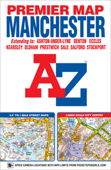
This A-Z Premier map of Manchester is a full colour, single sided, fold-out street map covering the whole of the M60 orbital motorway and extending to:*Kearsley*Whitefield*Oldham*Ashton-under-Lyne*Bredbury*Stockport*Broadheath*Irlam*Worsley*WalkdenAlso included is an inset map of Manchester International Airport. A large scale city centre map of Manchester and a Manchester Rail and Metrolink Connections map are featured on the inside of the cover.Postcode districts, one-way streets and safety camera locations with their maximum speed limits are featured on the street mapping.Attached to the cover is a booklet containing the index which lists streets, selected flats, walkways and places of interest, place and area names, National Rail stations and Metrolink stops, hospitals, hospices and NHS Walk-in Centres covered by this map.
Format:Map
Language:English
ISBN:1843489384
ISBN13:9781843489382
Release Date:June 2016
Publisher:Geographers’ A-Z Map Co Ltd
Length:1 Pages
Weight:0.48 lbs.
Dimensions:9.6" x 0.4" x 6.3"
Related Subjects
TravelCustomer Reviews
0 rating
Copyright © 2026 Thriftbooks.com Terms of Use
| Privacy Policy | Do Not
Sell/Share My Personal Information | Cookie Policy | Cookie Preferences | Accessibility Statement
ThriftBooks® and the ThriftBooks® logo are registered trademarks of Thrift Books Global, LLC
ThriftBooks® and the ThriftBooks® logo are registered trademarks of Thrift Books Global, LLC
