
London A-Z Premier Map
No Customer Reviews

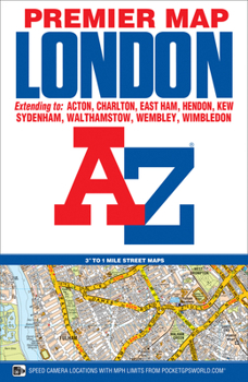
This A-Z map of London is a full colour, single sided, fold-out premier street map, covering a six mile radius from Charing Cross in central London and extending to Muswell Hill to the north, London City Airport to the east, Crystal Palace to the south and Wembley to the west.Postcode districts, one-way streets, the congestion zone boundary and safety camera locations with their maximum speed limit are featured on the mapping.Attached to the cover is a booklet containing the index which lists streets, selected flats, walkways and places of interest and place, area and junction names. Also included is a separate listing of National Rail, Docklands Light Railway, London Overground and London Underground Stations and a list of Hospitals and Hospices covered by this map.In addition, the full London Underground map is featured on the inside front cover.This map is now available at an enlarged scale of 5 inches to 1 mile (8 cm to 1 km). The London Knowledge Map is aimed primarily at people learning 'The Knowledge', it comes as a standard paper map or can be laminated allowing routes to be marked on the map with a dry marker then wiped clean or mounted on lightweight foam board. Supplied in 2 sections, the enlarged map can be butt joined as one if required.An A-Z map of London showing postcode districts (for example SW7) is also available.
Format:Paperback
Language:English
ISBN:1843488876
ISBN13:9781843488873
Release Date:February 2017
Publisher:Geographers' A-Z Map Company Ltd.
Length:1 Pages
Weight:0.45 lbs.
Dimensions:0.4" x 6.3" x 9.7"
Related Subjects
TravelCustomer Reviews
0 rating
Copyright © 2026 Thriftbooks.com
Terms of Use | Privacy Policy | Do Not Sell/Share My Personal Information | Cookie Policy | Cookie Preferences | Accessibility Statement
ThriftBooks ® and the ThriftBooks ® logo are registered trademarks of Thrift Books Global, LLC
ThriftBooks ® and the ThriftBooks ® logo are registered trademarks of Thrift Books Global, LLC
