
Glacier Peak, Wa No. 112
No Customer Reviews

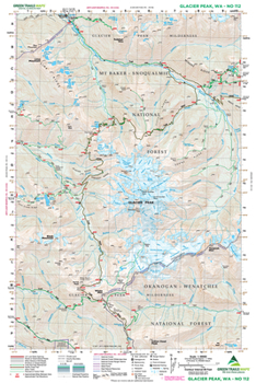
Far from roads and accessible only by long trail approaches, Glacier Peak is Washington's wildest volcano. This map captures the entire 10,541-foot volcano making it an excellent resource for ascending the peak. The Pacific Crest Trail travels high along the volcano's western slopes and is depicted on this map from Indian Head Peak to Miners Creek. The entire Suiattle River Trail as well as Miners Ridge and Image Lake are highlighted map 112 as well. You will also find on it, the upper North Fork Sauk River Trail, upper White River Trail, Lake Byrne, Fire Mountain, and Sulphur Mountain Trail. And scramblers interested in exploring Lime Ridge and its array of cirque cradling lakes will find this map invaluable. Original Edition 1977; Updated Edition 2014
Format:Map
Language:English
ISBN:1680513877
ISBN13:9781680513875
Release Date:February 2014
Publisher:Green Trails Maps
Related Subjects
TravelCustomer Reviews
0 rating
Copyright © 2026 Thriftbooks.com Terms of Use
| Privacy Policy | Do Not
Sell/Share My Personal Information | Cookie Policy | Cookie Preferences | Accessibility Statement
ThriftBooks® and the ThriftBooks® logo are registered trademarks of Thrift Books Global, LLC
ThriftBooks® and the ThriftBooks® logo are registered trademarks of Thrift Books Global, LLC
