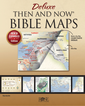
The NEW and EXPANDED Edition of the best-sellingDeluxe Then and Now Bible Maps With more than 30 new pages of highly detailed relief maps, full-color illustrations, and diagrams, this book lets you see where places of the Bible are today. The clear plastic overlays show modern cities and countries on top of beautifully rendered relief Bible maps.
This new edition has the same great content as the original book, plus so much more. All updated modern geography and an attractive new look to the Bible maps. Key points and features: 8 clear plastic overlays show modern places on top of Bible mapsSpiral binding allows pages to lie flat when openUses a larger, easier-to-read type than most Bible atlasesReproducible for classroom useWhat's NEW in this edition?
Old and New Testament Bible Maps: Greek and Roman EmpiresRoutes into the Promised LandWhere Jesus Walked in GalileeSeven Churches of RevelationBible Charts and Time Lines: ExodusJudges of IsraelArk of the CovenantTwelve Tribes of IsraelTwelve DisciplesMaps for Bible Stories: DavidSamsonRuthElijah and ElishaJesus' Journey to the CrossPlus all the maps are updated with a fresh new look
Discover Fascinating FactsThe book of Revelation begins with seven letters to seven churches. Those churches were located in cities near each other in modern-day Turkey.In the book of Ruth, Naomi and her family leave Bethlehem to escape a famine and they migrate to Moab. The land of Moab is located in modern-day Jordan.God sent Jonah to preach to Nineveh, which lies on the outskirts of modern-day Mosul, Iraq.When Moses fled Egypt he went to the land of Midian, which is in modern-day Saudi Arabia.An excellent way to make your Sunday School, homeschool, and Bible studies more interesting. This book uses larger, easier-to-read type than most Bible atlases. Get your copy today
I highly recommend the Deluxe Then and Now Bible Maps for homeschool use! The CD-ROM allows you to print out maps for more than one student and can be used for many different grade levels! We used them as templates to create our own poster-sized overlay maps!
Great Bible Study Help
Published by Thriftbooks.com User , 17 years ago
This book has been an excellent help in my Bible study, as it helps me locate the area I am reading about in the Bible and shows on the map overlay what that country is called now. Highly recommended.
A very useful collection
Published by Thriftbooks.com User , 17 years ago
The historical facts presented, with overlays of present-day situations are extremely useful for Bible study and teaching. The JPGs of the maps save so much of time in preparing notes and presentations.
MORE THAN MAPS!
Published by Thriftbooks.com User , 17 years ago
This is definitely a great source for finding Biblical locations and referencing them to present day geography however it is so much more than that. Biblical history is summarized in charts and diagrams. The Time Lines of the Old Testament and New Testament reference the books of the Bible to Biblical history, World history, and politcal rulers (Old Testament) of the time. Activities of Jesus' life are indexed by date on the NT Time Line. Much attention is given to Paul's travels in text as well as with maps. The fold-out maps(seperate item) are a great help to quickly locate areas however this source provides even more details to the maps and offers much more than can be summarized on the fold-outs.
Bible Maps with Clear Plastic Overlays Showing Modern Countries
Published by Thriftbooks.com User , 17 years ago
This is a full-color Bible atlas that includes the following Bible maps and clear plastic modern overlays showing today's cities and countries. Below is a listing of (1) each map, (2) each overlay, and (3) the contents of the CD-ROM and (4) how this product compares to other Bible map books on the market. #1 & #2 What maps and overlays are included? o The Middle East during Old Testament Times o Clear Overlay of modern-day Middle East o Map of the Assyrian Empire at three different time periods o Clear Overlay of same areas with modern-day countries o The Holy Land during the time of the Old Testament (12 Tribes) o Clear Overlay of modern-day Israel and surrounding countries o The Holy Land with territory of Kings Saul, David, and Solomon. o Clear Overlay of modern-day Israel and surrounding countries o The Holy Land showing the United and Divided Kingdoms o Clear Overlay of modern-day Israel and surrounding countries o Map of the Babylonian Kingdoms and Persian Empire o Clear Overlay of same areas with modern-day countries o The Holy Land during the time of Jesus (and a list of where Jesus walked) o Clear Overlay of modern-day Holy Land o Paul's Journeys (Roman Empire at AD 60) o Clear Overlay of modern-day Mediterranean area. o List of Paul's journeys and routes o Chart of Paul's letters (date, where written, and to whom) o Abraham's Journeys (2 maps) o Jacob's Journeys o Joseph's Journey to Egypt o The Exodus and Wilderness Wanderings o The Tabernacle layout (birds-eye view) o Map of Jerusalem at the time of Kings David and Solomon o Map of Jerusalem at the Time of Jesus o Tomb of Jesus o Chart of major and minor prophets, location, to whom they prophesied o Kingdoms of Daniel 2 o New Testament and Old Testament Time Line o Journeys of Peter and Philip o Expansion of Christianity in the Roman Empire o Index 3. On the CD-ROM o JPG's of all of the maps listed above, so that can be used in your own Bible material or make your own PowerPoint® presentations. If you don't have time to make your own PowerPoint presentation, there is a 50-slide presentation using the same maps: Then and Now Bible Maps: PowerPoint Presentation (PowerPoint Presentations). o PDF's of all of the maps listed above, so that can be used to make overhead transparencies or full-page handouts Larger type size than most Bible atlases. 4. How does this compare to the other Rose Publishing (and Ascension Press) Then and Now Bible Map books? 1. This book has 29 base maps (the other two have 8 base maps) 2. This book has 40 pages (the other two have 20 pages) 3. This book has 8 plastic overlays (the other two have 7) 4. This book has a CD-ROM that gives you all of the maps in a reproducible way (the other two are not reproducible and have no CD) 5. The book has a spine (the other two do not) 6. This book is $10 higher (list price) than the other two.
ThriftBooks sells millions of used books at the lowest everyday prices. We personally assess every book's quality and offer rare, out-of-print treasures. We deliver the joy of reading in recyclable packaging with free standard shipping on US orders over $15. ThriftBooks.com. Read more. Spend less.