
Columbia River Gorge West, or No. 428s
No Customer Reviews

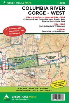
Roll on Columbia roll on with this special series map covering the Columbia Gorge National Scenic Area from Troutdale and Washougal east to Hood River and the White Salmon River. Plan day trips through Oregon's Waterfall Ally or long distance trail runs and backpacking trips within the Mark O Hatfield Wilderness. Map also includes the Washougal River valley, Oxbow Regional Park on the Sandy River, Beacon Rock State Park, and the Pacific Crest Trail from Waucoma Ridge to Three Corner Rock. Find epic hikes like Dog Mountain, Table Mountain, Eagle Creek, Larch Mountain and Angels Rest on this map; as well as less known destinations such as Franklin Ridge, Strawberry Island, Augspurger Mountain, Tomlike Mountain and Wygant Mountain.
Format:Loose Leaf
Language:English
ISBN:1680513737
ISBN13:9781680513738
Release Date:February 2014
Publisher:Green Trails Maps
Weight:0.39 lbs.
Dimensions:0.4" x 6.1" x 9.1"
Recommended
Format: Loose Leaf
Condition: New
$11.08
Save $2.92!
List Price $14.00
On Backorder
If the item is not restocked at the end of 90 days, we will cancel your backorder and issue you a refund.
Usually restocks within 90 days
Not eligible for Free Shipping 
Related Subjects
TravelCustomer Reviews
0 rating
Copyright © 2025 Thriftbooks.com
Terms of Use | Privacy Policy | Do Not Sell/Share My Personal Information | Cookie Policy | Cookie Preferences | Accessibility Statement
ThriftBooks ® and the ThriftBooks ® logo are registered trademarks of Thrift Books Global, LLC
ThriftBooks ® and the ThriftBooks ® logo are registered trademarks of Thrift Books Global, LLC
