
Columbia River Gorge East, or No. 432s
No Customer Reviews

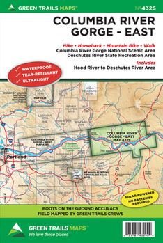
Discover the wide array of trails in the Gorge's eastern sunnier and drier reaches where waterfalls succumb to golden hillsides of resplendent wildflowers and impressive basaltic canyons. This special series map covers the Columbia River Gorge National Scenic Area from Hood River and White Salmon east to the Deschutes River and Maryhill. Map also includes detailed insets of some of the Eastern Gorge's best mountain biking areas; the Coyote Wall, Catherine Creek and Deschutes State Park. You'll also find the entire 31 mile long Klickitat Trail, Columbia Hills trail network, and The Dalles' Waterfront Trail on this map.
Format:Loose Leaf
Language:English
ISBN:1680513729
ISBN13:9781680513721
Release Date:February 2015
Publisher:Green Trails Maps
Weight:0.05 lbs.
Dimensions:0.1" x 5.7" x 8.8"
Recommended
Format: Loose Leaf
Condition: New
$10.99
Save $3.01!
List Price $14.00
On Backorder
If the item is not restocked at the end of 90 days, we will cancel your backorder and issue you a refund.
Usually restocks within 90 days
Not eligible for Free Shipping 
Save to List
Related Subjects
TravelCustomer Reviews
0 rating
Copyright © 2026 Thriftbooks.com Terms of Use
| Privacy Policy | Do Not
Sell/Share My Personal Information | Cookie Policy | Cookie Preferences | Accessibility Statement
ThriftBooks® and the ThriftBooks® logo are registered trademarks of Thrift Books Global, LLC
ThriftBooks® and the ThriftBooks® logo are registered trademarks of Thrift Books Global, LLC
