
Chiricahua Mountains, AZ No. 2934s
No Customer Reviews

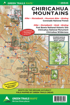
The largest mountain range in the Sky Islands; Southeastern Arizona's Chiricahua Mountains contain incredible biological diversity including 370 species of birds. Our map no. 2934S covers this fascinating range including all of the 87,700-acre Chiricahua Wilderness, the 12,000-acre Chiricahua National Monument, Emigrant Canyon, Wood Canyon, and the Fort Bowie National Historic Site. Use this map to explore this fascinating land of the Chiricahua Apaches led by Cochise and Geronimo. Hike through hoodoos and clusters of balancing rocks and old calderas. Wander through historic ranches or head out to find old mines. Hike along the Crest Trail to 9,763-foot Chiricahua Peak, the highest summit in the range and take in sweeping views that include peaks in New Mexico and Mexico. Map includes a larger scale (1:40,000) inset of the Cave Creek Canyon and Rustler Park areas. Here wander easy nature trails or make the exhilarating hike to the historic lookout site on 8008-foot Silver Peak.
Format:Loose Leaf
Language:English
ISBN:1680513672
ISBN13:9781680513677
Release Date:February 2018
Publisher:Green Trails Maps
Weight:0.30 lbs.
Dimensions:0.3" x 5.7" x 8.4"
Recommended
Format: Loose Leaf
Condition: New
$10.99
Save $3.01!
List Price $14.00
On Backorder
If the item is not restocked at the end of 90 days, we will cancel your backorder and issue you a refund.
Usually restocks within 90 days
Not eligible for Free Shipping 
Save to List
Related Subjects
TravelCustomer Reviews
0 rating
Copyright © 2026 Thriftbooks.com Terms of Use
| Privacy Policy | Do Not
Sell/Share My Personal Information | Cookie Policy | Cookie Preferences | Accessibility Statement
ThriftBooks® and the ThriftBooks® logo are registered trademarks of Thrift Books Global, LLC
ThriftBooks® and the ThriftBooks® logo are registered trademarks of Thrift Books Global, LLC
