


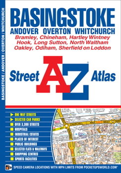
Basingstoke A-Z Street Atlas
No Customer Reviews

This A-Z map of Basingstoke is a full colour street atlas featuring 36 pages of street mapping covering: -Basingstoke-Bramley-Sherfield on Loddon-Hartley Wintney-Hook-Odiham-South Warnborough-North Waltham-Oakley-Sherborne St. John-ChinehamThere is also separate coverage of: -Andover-Whitchurch-OvertonPostcode districts, one-way streets and safety camera locations with their maximum speed limit are featured on the mapping.The index section lists streets, selected flats, walkways and places of interest, place, area and station names, hospitals and hospices covered by this atlas.This Basingstoke map is ideal for residents and visitors alike.
Format:Paperback
Language:English
ISBN:1843489104
ISBN13:9781843489108
Release Date:September 2012
Publisher:Geographers’ A-Z Map Co Ltd
Length:52 Pages
Weight:0.21 lbs.
Dimensions:8.5" x 0.1" x 5.9"
Related Subjects
TravelCustomer Reviews
0 rating
Copyright © 2026 Thriftbooks.com
Terms of Use | Privacy Policy | Do Not Sell/Share My Personal Information | Cookie Policy | Cookie Preferences | Accessibility Statement
ThriftBooks ® and the ThriftBooks ® logo are registered trademarks of Thrift Books Global, LLC
ThriftBooks ® and the ThriftBooks ® logo are registered trademarks of Thrift Books Global, LLC
