

Archaeology and Landscape in the Mongolian Altai: An Atlas

An atlas that examines the distribution of ancient surface archaeological discoveries within the mountainous region of northwestern Mongolia. It presents the cultural heritage of this rugged... This description may be from another edition of this product.
Format:Hardcover
Language:English
ISBN:1589482328
ISBN13:9781589482326
Release Date:December 2009
Publisher:Esri Press
Length:209 Pages
Weight:4.30 lbs.
Dimensions:0.9" x 11.2" x 11.2"
Customer Reviews
2 ratings
Visualy stunning atlas
Published by Thriftbooks.com User , 14 years ago
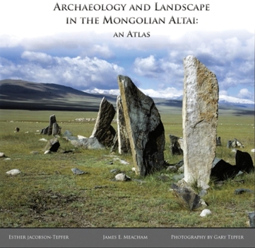
This visually stunning book is also a remarkable scholarly accomplishment. Until its publication, none of the roughly 30,000 inhabitants of the Mongolian Altai knew more than a small part of the region and very few outsiders had even entered the area. No reliable maps existed. Now accurate maps and photographs document the thousands of archaeological sites for the whole world to see. The heart of this study is the relationship between the various ancient stone monuments and the landscape in which they were contructed. Fifteen years of intensive work was aided by friendships nurtured with the local herders and by western technology. The atlas shows the western 2 or 3% of the huge Mongolian nation in incredible detail. Here wide treeless valleys stretch down from the Altai mountains which mark the boundary between Mongolia on the east, Russian Siberia on the north and China's northern Xinjiang Autonomous Region on the southwest. These mountains attain their highest summit at Mount Khuitan, 4,374 meters (14,350 feet) above sea level. All of Mongolia has an area of about 1,564,000 square kilometers (604,000 square miles), almost twice as big as Texas but a population of less than 3,000,000. The Altai mountain basin is even more sparsely populated so that sweeping vistas seldom show any sign of contemporary humans. Most of the pictures and maps focus on a huge array of stone monuments and carvings left mainly over the last 4,000 years and generally undisturbed because they are still venerated by the very few people who ever see them. The recent sparse beginnings of tourism put their continued survival at risk. Just over a century ago V. V. Sapozhinskov was the first outsiders to travel the Mongolian Altai. The three authors of this atlas are art historian/anthropologist Esther Jacobson-Tepfer and her husband photographer Gary Tepfer who have visited the region repeatedly, and James E. Meacham who used his cartographic skills to transfer their numerous observations into an outstanding atlas. For the non-scholar and non-cartographer, the numerous photographs will be the treasure of this book. They show sweeping views of this unknown area which the ancient monuments were intended to celebrate and enhance. Snow capped mountains are often in the distance, but trees are far less common.
A singularly stunning coffee table book, highly recommended especially to armchair travelers
Published by Thriftbooks.com User , 14 years ago
Archaeology and Landscape in the Mongolian Altai: An Atlas is an extraordinary reference presenting the exploration and survey of one of the last, remote corners of the world to be cartographically documented. In 1994, authors Esther Jacobson-Tepfer and James E. Meacham began to survey the western-most part of the Mongolian Altai, and their findings - including tremendously beautiful color photographs, detailed maps, and vividly detailed verbal descriptions accessible to readers of all backgrounds - are offered not only as a scholarly reference, but also as a testimony to the wonder of the rugged natural world. A singularly stunning coffee table book, highly recommended especially to armchair travelers.
Copyright © 2023 Thriftbooks.com Terms of Use | Privacy Policy | Do Not Sell/Share My Personal Information | Cookie Policy | Cookie Preferences | Accessibility Statement
ThriftBooks® and the ThriftBooks® logo are registered trademarks of Thrift Books Global, LLC
ThriftBooks® and the ThriftBooks® logo are registered trademarks of Thrift Books Global, LLC
