
50 Miles Around Bristol A-Z Road Map
No Customer Reviews

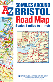
This A-Z 50 Miles around Bristol map is a full colour, single sided, fold-out road map featuring continuous mapping extending to include Worcester and Stratford-upon-Avon to the north, Witney and Andover to the east, Bournemouth and Lyme Regis to the south and Minehead and Bridgend to the west.*Published at a clear 3 miles to 1 inch the following features are shown on the road mapping:Motorways open with full junction detail, motorways under construction and proposed, service areas, primary routes and destinations, A & B roads, selected minor roads, gradients 1:5 and steeper, tolls, mileages, national and county boundaries, spot heights and hill shading.*Selected safety camera locations with maximum speed limits.*Selected fuel stations.*A wide range of ancillary and tourist information.*Brecon Beacons, New Forest and Exmoor National Park boundaries.The index to cities, towns, villages, hamlets and locations is adjacent to the map.
Format:Paperback
Language:English
ISBN:1782570543
ISBN13:9781782570547
Release Date:January 2018
Publisher:Geographers' A-Z Map Company Ltd.
Length:1 Pages
Related Subjects
TravelCustomer Reviews
0 rating
Copyright © 2026 Thriftbooks.com Terms of Use
| Privacy Policy | Do Not
Sell/Share My Personal Information | Cookie Policy | Cookie Preferences | Accessibility Statement
ThriftBooks® and the ThriftBooks® logo are registered trademarks of Thrift Books Global, LLC
ThriftBooks® and the ThriftBooks® logo are registered trademarks of Thrift Books Global, LLC
