
Washington Pass, Wa No. 50
No Customer Reviews

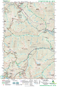
This map encompasses a large wild roadless area north and east of the North Cascades Highway. With it you can plan some breathtaking trips. The classic day hikes to Cutthroat Pass and Maple Pass, larch lined Blue Lake, and wildflower-studded Driveway Butte are on this map. The spectacular Snowy Lakes beneath the impressive spires of the Golden Horn and Tower Mountain are on Map 50 as well. And this map covers the Pacific Crest Trail from Rainy Pass to Windy Pass and the West Fork Methow River feeder trail. Robinson Creek and Robinson Mountain--a popular climbing destination are also covered as well as Harts Pass--reached by a white knuckle Forest Service road--the highest public road in Washington. Reprinted 2023
Format:Map
Language:English
ISBN:1680515039
ISBN13:9781680515039
Release Date:February 2014
Publisher:Green Trails Maps
Length:2 Pages
Related Subjects
TravelCustomer Reviews
0 rating
Copyright © 2026 Thriftbooks.com
Terms of Use | Privacy Policy | Do Not Sell/Share My Personal Information | Cookie Policy | Cookie Preferences | Accessibility Statement
ThriftBooks ® and the ThriftBooks ® logo are registered trademarks of Thrift Books Global, LLC
ThriftBooks ® and the ThriftBooks ® logo are registered trademarks of Thrift Books Global, LLC
