
Mount Rainier West, Wa No. 269
No Customer Reviews

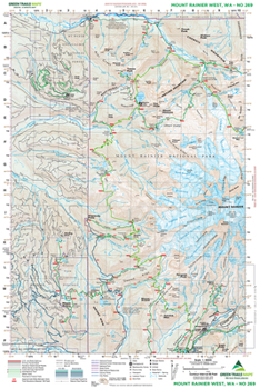
If you're planning on doing any hiking or backpacking in Mount Rainier National Park's Longmire, Mowich Lake, and Carbon River areas, this is the map you want in your pack. The entire western half of Mount Rainier National Park as well as the Evans Creek ORV trail system and Glacier View Wilderness area are covered on it. Map 269 also displays the iconic mountain's 14,411-foot summit and many of its glaciers including the Carbon and Tahoma. If you're Wonderland Trail bound, this historic trail from the Paradise River to Mystic Lake along with the camps in between are displayed. The Yellowstone Cliffs, Carbon River Trail, Green Lake, Kautz Creek Trail, Van Trump Park, Rampart Ridge, and Comet Falls Trails as well as other popular day hiking destinations are also highlighted on this map.
Format:Map
Language:English
ISBN:1680514369
ISBN13:9781680514360
Release Date:February 2014
Publisher:Green Trails Maps
Length:2 Pages
Related Subjects
TravelCustomer Reviews
0 rating
Copyright © 2026 Thriftbooks.com
Terms of Use | Privacy Policy | Do Not Sell/Share My Personal Information | Cookie Policy | Cookie Preferences | Accessibility Statement
ThriftBooks ® and the ThriftBooks ® logo are registered trademarks of Thrift Books Global, LLC
ThriftBooks ® and the ThriftBooks ® logo are registered trademarks of Thrift Books Global, LLC
